WELCOME TO TERPGUY WEATHER AND STUFF
2024 TROPICAL OUTLOOKS...BELOW
5 MAY, 0805 DST
HAPPY CINCO DE MAYO
CURRENT CONDITIONS AT TERPGUY WEATHER CENTER:
@0810
OVERCAST, RAIN
TEMPERATURE = 53°F
HUMIDITY = 99%
AIR QUALITY- 27 GOOD
SATURDAY'S RAINFALL AT 0700 SUNDAY = TBD, ±0.50"??
COD MAP, 0830
(how you can get this, FREE, at the bottom)
NORTH- 0810
LAWN GREEN = COASTAL FLOOD ADVISORY: UP TO ONE-HALF FOOT INUNDATION; *StMCo- SUNDAY, 0900 UNTIL 1500; UP TO ONE FOOT INUNDATION; *Dor/Wic/SomCos- SUNDAY, 2100,UNTIL MONDAY, 0600; *DC- UNTIL SUNDAY, 0900...
| |
PURPLE =
SMALL CRAFT ADVISORY:
CHESBAY/POTRIV/PAXRIV- UNTIL AS LATE AS 1800 SUNDAY...
HAZARDOUS WEATHER:
WESTERN SHORE-
SMALL CRAFT STATEMENTS;
TIDAL FLOODING STATEMENTS...
COASTAL FLOOD STATEMENTS- SUN, MON, TUE;
SMALL CRAFT STATEMENTS- CHESBAY...
LOWER DELMARVA-
SMALL CRAFT STATEMENTS- CHESBAY...
WEATHER FORECAST,
SUNDAY:
WESTERN SHORE- NORTH:
Sunday, 5 May: Pre-2-ish rain, then showers, perhaps 0.50". Clouds, m-60s. Wind SE, 9.
Sunday night: Chance of pre-2-ish showers. Some overnight fog. Clouds, lo-60s. Wind S, 7.
Monday, 6 May: Some AM fog. Small chance of pre-7-ish showers, then a post-2-ish chance of showers and TSs. Clouds, up-70s. Wind W, 5.
Below is subject to change:
Monday night: showers?-TSs? (early)--> showers??/clouds, 60°. Wind L&V, to AM NW, 6.
Tuesday, 7 May: PM showers?-TSs?/some sun, up-70s. Wind NW, 6, to PM S.
Tuesday night: showers?-TSs?-->AM showers??/clouds, lo-60s.
Wednesday, 8 May: PM showers?/sun, lo-80s.
Wednesday night: showers?/clouds, lo-60s.
Thursday, 9 May: showers, add PM TSs?/clouds, m-70s.
Thursday night: showers-TS? (early)-->showers?-TSs?/clouds, up-50s.
Friday, 10 May: showers?/sun, lo-70s.
Friday night: showers?/clouds, lo-50s.
Saturday, 11 May: showers?/sun, m-60s.
WESTERN SHORE- INLAND:
Sunday, 5 May: Pre-2-ish rain, then showers, perhaps 0.50". Clouds, m-60s. Wind SE, 9.
Sunday night: Chance of pre-2-ish showers. Some overnight fog. Clouds, lo-60s. Wind S, 7.
Monday, 6 May: Some AM fog. Small chance of pre-7-ish showers, then a post-2-ish chance of showers and TSs. Clouds, up-70s. Wind W, 5.
Below is subject to change:
Monday night: showers?-TSs? (early)--> showers??/clouds, 60°. Wind L&V, to AM NW, 6.
Tuesday, 7 May: PM showers?-TSs?/some sun, up-70s. Wind NW, 6, to PM S.
Tuesday night: showers?-TSs?-->AM showers??/clouds, lo-60s.
Wednesday, 8 May: PM showers?/sun, lo-80s.
Wednesday night: showers?/clouds, lo-60s.
Thursday, 9 May: showers, add PM TSs?/clouds, m-70s.
Thursday night: showers-TS? (early)-->showers?-TSs?/clouds, up-50s.
Friday, 10 May: showers?/sun, lo-70s.
Friday night: showers?/clouds, lo-50s.
Saturday, 11 May: showers?/sun, m-60s.
WESTERN SHORE- SOUTH:
Saturday, 4 May: Pre-11-ish showers, then pre-2-ish showers and a poss-TS, THEN showers. Clouds, lo-60s. Wind E, 10.
Saturday night: Post-2-ish showers. Clouds, m-50s. Wind E, 10.
Sunday, 5 May: Showers, clouds, lo-70s. Wind SE, 11, gusts to 16.
Below is subject to change:
Monday, 6 May: AM showers??-->showers??-TSs??--> showers, poss-TS/clouds, lo-80s. Wind SW, 7.
Monday night: showers-TSs? (early)-->showers?-TSs?/clouds, m-60s.
Tuesday, 7 May: showers?/some sun, up-70s.
Tuesday night: showers? (early)-->showers?-TSs?/clouds, lo-60s.
Wednesday, 8 May: PM showers?/some sun, m-80s.
Wednesday night: showers? (early)-->showers?-TSs?
-->showers??/clouds, m-60s.
Thursday, 9 May: showers-TS?/clouds, lo-80s.
Thursday night: showers-TSs/clouds, lo-60s.
Friday, 10 May: showers?/some sun, up-70s.
DELMARVA- NORTH:
Saturday, 4 May: Post-2-ish showers. Clouds, 60°. Wind E, 8.
Saturday night: Post-2-ish showers. Clouds, 50°. Wind E, 8.
Sunday, 5 May: Showers, perhaps 0.25". Clouds, m-60s. Wind SE, 10.
Below is subject to change:
Sunday night: showers-TS?-->AM showers?-TSs?
-->showers?/clouds, up-50s. Wind SE, 6.
Monday, 6 May: AM showers?-add poss-TSs/clouds, up-70s. Wind W, 6.
Monday night: showers?-TSs?/clouds, lo-60s.
Tuesday, 7 May: showers?/some sun, up-70s.
Tuesday night: showers?/clouds, lo-60s.
Wednesday, 8 May: PM showers?-TSs?/some sun, lo-80s.
Wednesday night: showers?-TSs?/clouds, lo-60s.
Thursday, 9 May: showers-TS?/clouds, up-70s.
Thursday night: showers-TSs/clouds, up-50s.
Friday, 10 May: showers?/some sun, m-70s.
DELMARVA- CENTRAL:
Saturday, 4 May: Scattered showers. Clouds, up-50s. Wind E, 10.
Saturday night: Chance of showers. Clouds, lo-50s. Wind E, 10.
Sunday, 5 May: Chance of showers. Clouds, lo-70s. Wind SE, 13.
Below is subject to change:
Sunday night: AM showers/clouds, lo-60s. Wind S, 10.
Monday, 6 May: showers?, add poss-TSs?/clouds, lo-80s. Wind SW, 10.
Monday night: showers?-TSs?/clouds, lo-60s.
Tuesday, 7 May: showers?/some sun, 80°.
Tuesday night: showers?/clouds, lo-60s.
Wednesday, 8 May: some sun, m-80s.
Wednesday night: showers?-TSs? (early)-->AM showers?/clouds, lo-60s.
Thursday, 9 May: showers?-TS?/clouds, up-70s.
Thursday night: showers?-TSs?/clouds, 60°.
Friday, 10 May: showers?/some sun, up-70s.
DELMARVA- SOUTH:
Saturday, 4 May: Pre-2-ish showers. Clouds, up-50s. Wind E, 10.
Saturday night: Small chance of post-2-ish showers. Clouds, lo-50s. Wind E, 10.
Sunday, 5 May: Post-2-ish showers. Clouds, 70°. Wind S, 11.
Below is subject to change:
Sunday night: showers?/clouds, lo-60s. Wind S, 8.
Monday, 6 May: showers??-->PM showers?-TSs?/clouds, 80°. Wind SW, 9.
Monday night: showers?-TSs? (early)-->showers--> both?/clouds, m-60s.
Tuesday, 7 May: showers?, add PM TSs?/some sun, up-70s.
Tuesday night: showers?-TSs?(early)--> showers?/clouds, lo-60s.
Wednesday, 8 May: some sun, m-80s.
Wednesday night: showers?-TSs?-->AM showers?/clouds, m-60s.
Thursday, 9 May: showers?-TSs?/clouds, lo-80s.
o-6
Thursday night: showers?-TSs?/clouds, lo-60s.
Friday, 10 May: showers?/some sun, up-70s.
OCEAN SHORE:
Saturday, 4 May: Chance of pre-2-ish showers. Clouds, m-50s. Wind E, 15.
Saturday night: Small chance of post-2-ish showers. Clouds, lo-50s. Wind E, 15.
Sunday, 5 May: Small chance of pre-8-ish showers, then a small chance of post-2-ish showers. Clouds, lo-60s. Wind SE, 14.
Below is subject to change:
Sunday night: showers? (early)/clouds, 60°. Wind S, 11.
Monday, 6 May: showers??-->PM showers?-TSs?/clouds, up-60s. Wind SW, 10.
Monday night: showers?-TSs?/clouds, 60°.
Tuesday, 7 May: showers?/some sun, up-70s.
Tuesday night: showers?/clouds, lo-60s.
Wednesday, 8 May: PM showers?-TSs?/some sun, lo-80s.
Wednesday night: showers?-TSs?/clouds, lo-60s.
Thursday, 9 May: showers?-TS?/clouds, lo-70s.
Thursday night: showers-TSs/clouds, up-50s.
Friday, 10 May: showers/some sun, m-70s.
2024 TROPICAL FORECAST- APRIL, 2024:
Colorado State University-
NAMED STORMS- 23...AVERAGE 14
HURRICANES- 11...AVERAGE 8
MAJOR HURRICANES (Cat 3+)- 5... AVERAGE 2
(updates as they come)
National Hurricane Center-
NAMED STORMS- 20...AVERAGE 14
HURRICANES- 9...AVERAGE 8
MAJOR HURRICANES (Cat 3+)- 4... AVERAGE 2
(updates as they come)
2024 Atlantic/Gulf Hurricane Names:
Alberto Helene Oscar
Beryl Isaac Patty
Chris Joyce Rafael
Debby Kirk Sara
Ernesto Leslie Tony
Francine Milton Valerie
Gordon Nadine William
SPACE WEATHER-
MAY, 2024
Moon, Planets, Events, etc.
They will ask you to join, but it is FREE (but has ads)...
GOES MAP:
KEYS TO WEATHER CODES:
ZR = FREEZING RAIN
ZF = FREEZING FOG
ZD = FREEZING DRIZZ
IP = SLEET
LONA = Little Or No Accumulation
WIND:
XX = NEAR GALE: 32-38
XX = GALE FORCE: 39 and up
KNOT = 1.15MPH
RAIN VS. SHOWERS:
rain is steady...showers are off and on.
For TGWS:
DARK
VIOLET = STORM WARNING:
PLUM = GALE
WARNING
PINK = GALE WATCHXXX
GOLDENROD = HIGH WIND WARNING:
VIOLET-PURPLE = STORM WARNING:
HOT PINK =WINTER STORM
WARNING
PALE
VIOLET RED =SEVERE THUNDERSTORM WATCH
ORANGE
VIOLET-PURPLE = WINTER
WEATHER ADVISORY
DARK MAGENTA = ICE
STORM WARNING
BLUE-PURPLE = WINTER STORM WATCH: #0059C4; XXXX
CORNFLOWER BLUE
= FROST ADVISORY
CYAN = FREEZE WATCH
DARK SLATE BLUE = FREEZE WARNING: (COLOR CORRECTED)
DARK RED =
FLASH FLOOD WARNING
|
LIME = FLOOD WARNING
SPRING GREEN = FLOOD ADVISORY
LAWN GREEN = COASTAL FLOOD ADVISORY SEA GREEN = FLOOD WATCH
|
|
OLIVE DRAB = COASTAL FLOOD STATEMENTS;
MEDIUM AQUAMARINE = COASTAL FLOOD WATCH
FOREST GREEN =
COASTAL FLOOD WARNINGS
TURQUOISE = BEACH/RIP
MEDIUM ORCHID = HIGH SURF ADVISORY ZZ
DEEP PINK = RED FLAG WARNING
CORAL = HEAT ADVISORY
MEDIUM VIOLET-RED = EXCESSIVE HEAT WARNING
MAROON = EXCESSIVE HEAT WATCH:
The College of DuPage is a public university outside of Chicago with one of the finest Meteorology Programs in the world!
Their excellent maps reload every six minutes!
HOW TO ACCESS THE C.O.D. MAP:
IT'S FREE!
1) GO TO:
https://weather.cod.edu/
2) CLICK ON "WEATHER ANALYSIS TOOLS":

3a) CLICK ON "SATELLITES AND RADAR":
3b) GO TO LOWER LEFT OF PAGE:
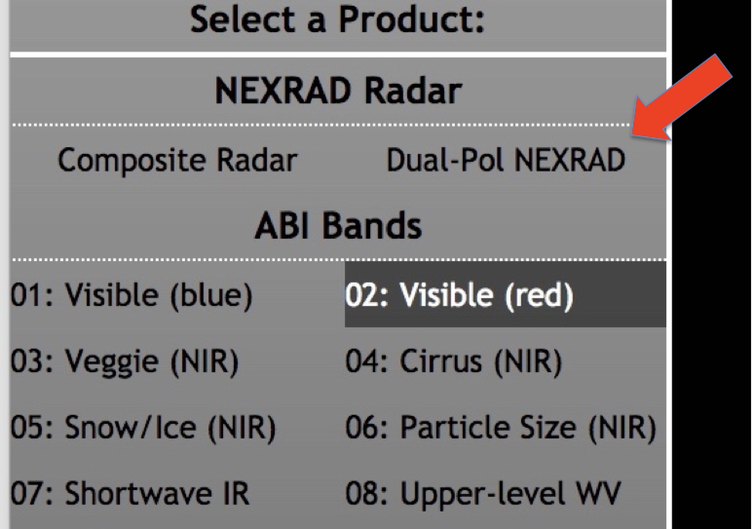
3c) CLICK ON "Dual-Pol NEXRAD":
4) YOU'LL GET THIS RADAR MAP OF COLLEGE OF DUPAGE'S AREA (NEAR LAKE MICHIGAN):
5) CLICK ON THIS ICON:
 6) CHOOSE YOUR RADAR SITE


 6) CHOOSE YOUR RADAR SITE